Brief description of fishery:
The Tay has the largest catchment within the British Isles, covering an area of 6475 square kilometers. The River Tay flowing from the headwaters to the North Sea travels over a distance of 160 KM.
The main stem of the system, the River Tay, is joined by smaller rivers and tributaries such as the Earn, Almond, Isla and Ericht, Tummel, Garry, Tilt and Errochty, Lyon, Dochart and Lochay, and also the rivers Ba and Gaur that lie some 10 kilometers from the West Coast of Scotland. The Tay catchment also includes a number of important Lochs such as the Tay, Earn, Tummel, Rannoch, Faskally, Dochart, and Laidon.
The River Tay is one of the most prestigious salmon angling rivers in Europe, and the waters of the Tay catchment are a magnet to many thousands of trout, grayling, and coarse anglers every year.
The sheer scale of the Tay system is reflected in the variety of organizations with interests in the management of fisheries resources.
KBAC has access to the west banks of Loch Tay, Rivers Dochart, and Lochay including hill lochs Leehan nan Lairigc, to the North of Loch Tay, and Lochan Brcaclaich to the South of Loch Tay, along with Lochan nan Cat on the Ben Lawers Nature Reserve, and Lochan nan Geadas to the South of Loch Tay. (Please see our detailed guides for specifics as this is a brief description of our beat)
Special Rules for this fishery:
Night ticket is available after 1 years membership. Day Tickets are available online.
Address
Killin, Perthshire
Parking & Access
Killin is a small village at the Falls of Dochart, a spectacular series of rapids, at the western end of Loch Tay.
The village makes an excellent base for walks in the surrounding mountains of Breadalbane while Loch Tay is a popular destination for both its salmon fishing and watersports. Killin sits at the edge of the Ben Lawers National Nature Reserve and the Loch Lomond & The Trossachs National Park, so you can enjoy a lovely mix of wildlife spotting, outdoor activities, and walking.
Nearby you will find the ruins of the Campbell stronghold of Finlarig Castle and the Moirlanich Longhouse, a rare surviving example of a traditional Scottish longhouse, maintained by the National Trust for Scotland.
The village offers a variety of accommodation, places to eat, and local convenience stores. The Killin Outdoor Centre and Mountain Shop have a variety of outdoor equipment for hire and sale and can provide excellent knowledge for things to see and do in the area.
From Perth and the East
From the A9 (north or southbound), take the A827, signposted for Aberfeldy, continue on the A827 through Kenmore, along the North Banks of Loch Tay finally arriving in Killin.
From Edinburgh
Heading North on the M9, depart the motorway at Juntion 10. Take the A84, following signs for Callander, Starthyre, Lochearnhead. At Lochearnhead head the road name changes to the A85 (but continues straight).10 Metres before the Lix Toll Garage, turn right onto the A827 and onto Killin.
From Glasgow
Take the M8 West towards Edinburgh, following signs for Stirling. Leaving the motorway for the M80, and merging onto the M9 North for Stirling. At Juntion 10. take the A84, following signs for Callander, Starthyre, Lochearnhead. At Lochearnhead head the road name changes to the A85 (but continues straight).10 Metres before the Lix Toll Garage, turn right onto the A827 and onto Killin.
Public Transport
It is possible to reach Killin via public transport, the links below should assist you, if these aren’t helpful, please email us for assistance and we’d be happy to help.
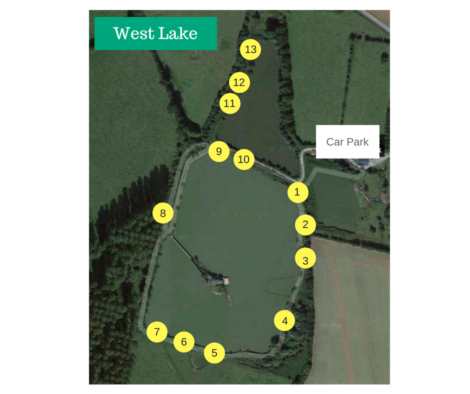
Maps


Species
- Brown Trout
- Perch
- Pike
- Rainbow Trout
- Salmon